GIS toolbox for noise remediation MJPG
Together with Arcadis, we are involved in the acoustic research to determine the extent of the noise measures for the MJPG of Rijkswaterstaat. Our acoustic research covers plot 2, which roughly covers the area of the provinces of Utrecht and South Holland. In the investigation of the noise measures, we have collected large amounts of geographical data files. M+P has developed a toolbox in ArcGIS for combining, editing and checking this data, and this reduces a large amount of manual work to a few button presses. This automation saves time, energy and costs, and also leads to more clarity and fewer errors.
The development presented all kinds of challenges: project management, interpretation of laws and regulations, user wishes and technical challenges, both in the field of GIS and in the field of software engineering. We are proud of the result.
The Multi-Year Noise Control Programme
When the new SWUNG legislation came into effect, a new approach to noise control for excessive noise that currently exists along roads and railways was also included. This new noise control is part of the MJPG. M+P worked with Arcadis on the acoustic study to determine the extent of the required noise measures for part of the Dutch national roads, consisting of quiet road surfaces and noise barriers.
Acoustic research and design of noise measures
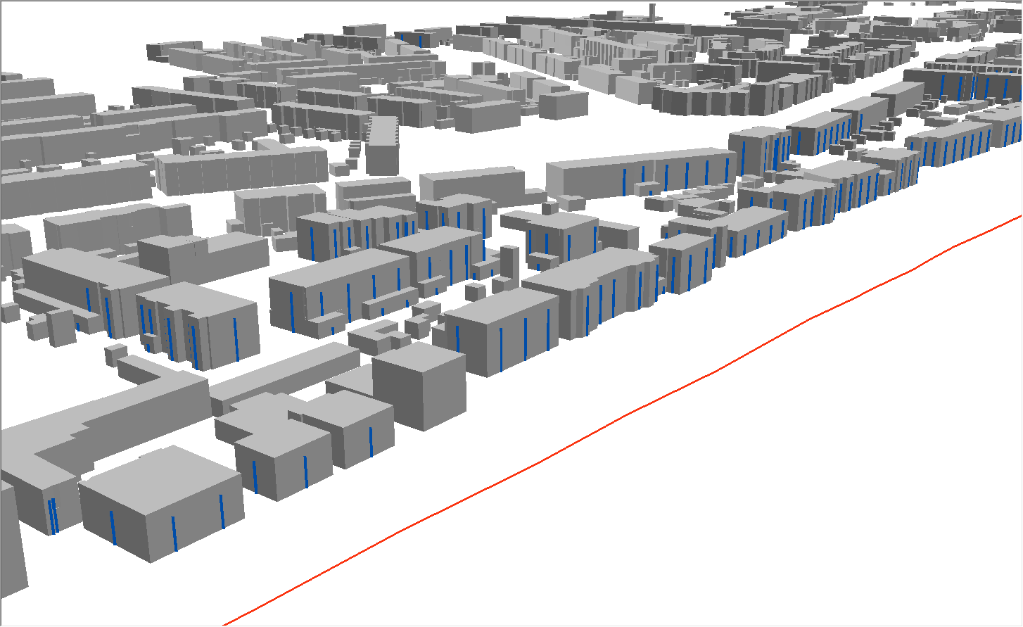
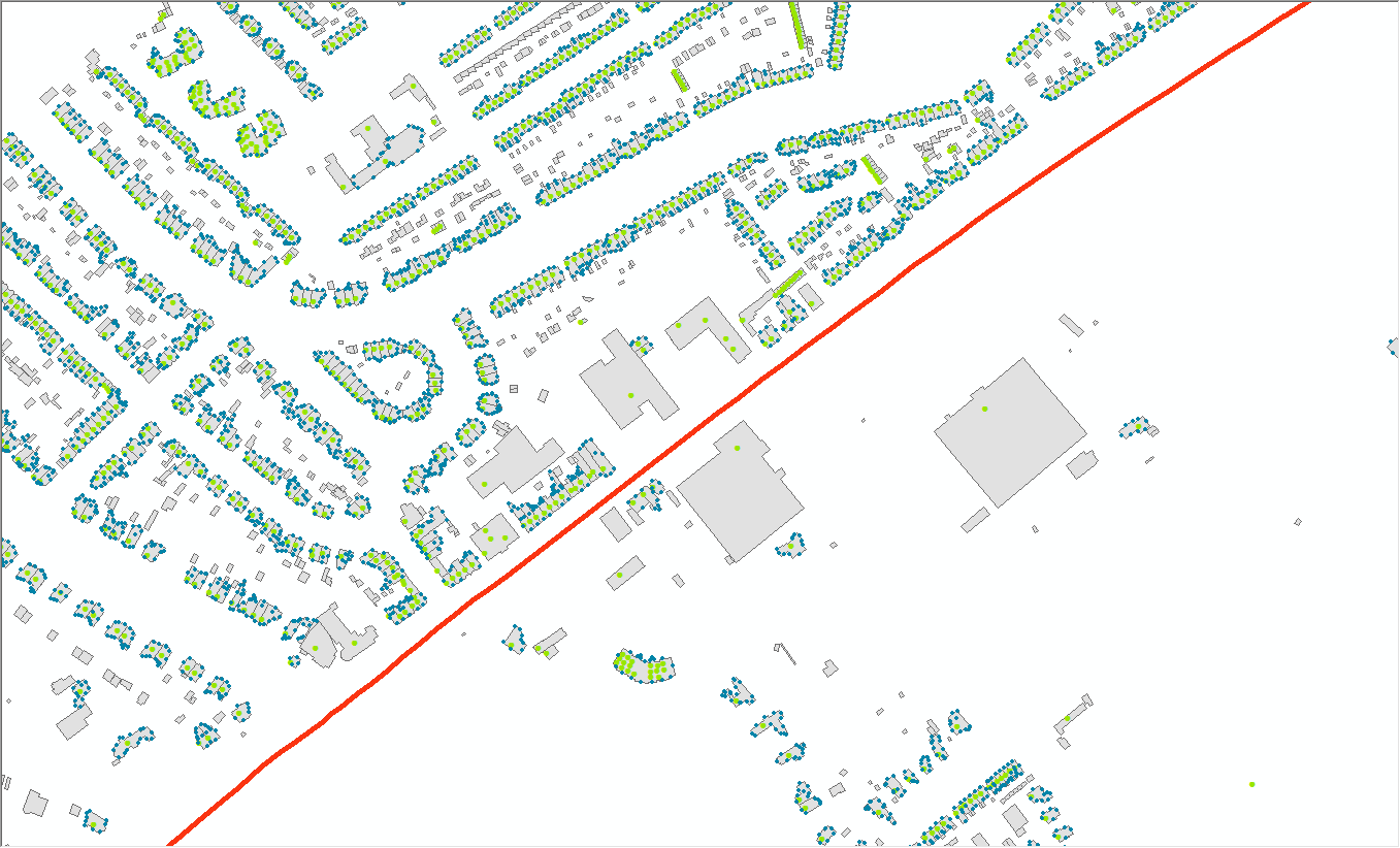
Different geographical data files must be combined for the acoustic research. This includes the location of all national motorways, with the different lanes and entrances and exits, and the associated data on traffic intensities, speeds and road surface types. These data have been taken from the RWS noise register. The data on existing noise barriers also comes from the register. We have added data about the location of all homes and other noise-sensitive objects from the BAG. And since all this data is defined in the flat plane, we also added the elevation information using the DTB and AHN.
The combination of all this data requires complex geographic operations and comprehensive, rigorous control of input data and results. No data file is completely error-free, and the combination of different files presents challenges for accuracy.
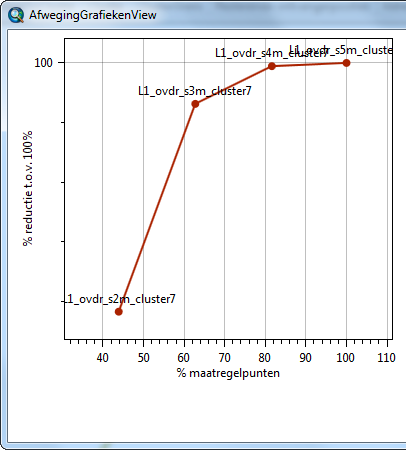
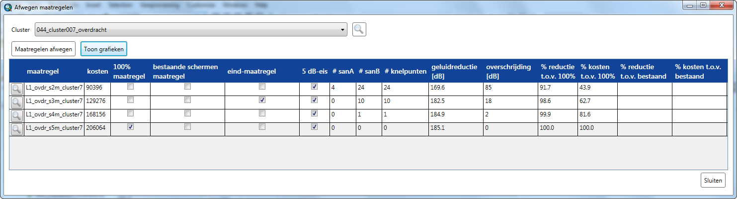
When the whole 3D model of the source and environment was ready, the acoustic calculations were started. The noise advisers put together various packages of measures, using the information provided by the toolbox. This involves low-noise road surfaces, such as two-layer ZOAB, and noise screens of different length and height, which of course must be in the right place. For each of the different options of measures that can be taken, the financial efficiency must then be weighed. This is done according to the Kader Doelmatigheidscriterium Geluidmaatregelen (Kader DMC) [Framework Efficiency Criterion Noise Measures] that Rijkswaterstaat has drawn up. The cost-effectiveness of each type of measure has been determined: does the measure provide sufficient noise reduction in relation to the construction and maintenance costs?
GIS toolbox
For such an extensive research area, it is unwise to perform all these activities and calculations manually. M+P, in collaboration with colleagues from Arcadis, has therefore developed a toolbox in ArcGIS, which automates the most important and most labour-intensive activities. First, we developed tools for checking, adjusting and extending the basic data:
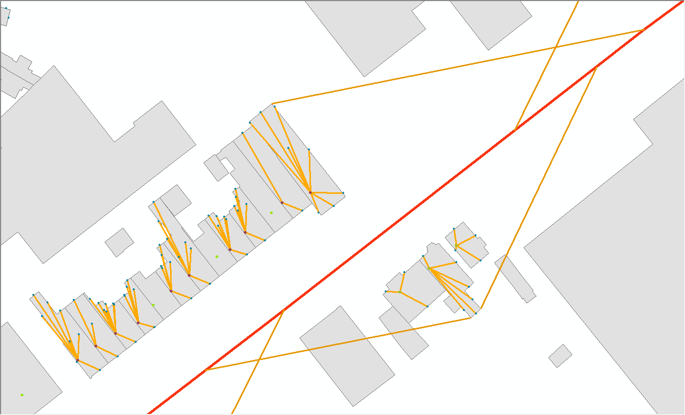
- Receiver points are generated for all buildings, on all façades, at different heights depending on the height of the building. Some situations still require manual adjustment: in such a large area you will encounter the most erratic shapes of buildings, so you still want to move, remove or add some calculation points. It is precisely this that poses the biggest challenge for our software programmers: how do you allow manual operations without disrupting the automated system?
- The driving lanes in the noise register are only designed for one location, while in reality the roadway consists of several lanes. Using the toolbox, it was possible to duplicate and shift the driving lanes automatically, to distribute the intensities correctly over the duplicated driving lanes, and to correct the point pieces at entrances and exits.
Based on the first noise calculations, the addresses that form a noise control bottleneck will then be determined. Apart from the question of how the software can automatically determine the bottlenecks, this also includes the legal question of when a particular object is exactly a noise control bottleneck, and what noise reduction must be achieved for this object.
The bottleneck locations are automatically divided into clusters by determining the viewing angle of each object on the road and combining overlapping viewing angles according to the rules of the DMC.
The design of the measures was a task for the acoustic consultants of Arcadis and M+P, in consultation with experienced designers from Arcadis. The noise reduction for the various measures is determined with acoustic calculation software (GeoMilieu), after which the results are fed back into our GIS database:
- The efficiency assessment is then carried out by the software for each type of measure, so that the consultant has all the information to determine the most effective measure.
- For the reporting of the results, the tool provides clear tables for all results, per home and per measure.
Results
The GIS toolbox was developed by M+P, whereby Arcadis colleagues used their expertise to clarify the wishes of users and test the software extensively. The tool removes a lot of tedious and sometimes annoying manual labour and allows the consultants to focus on the most important work, which is to design the measures. The tool also leads to an unambiguous working and reporting method.
All in all, a useful and educational development process, with challenges at all levels: project management, interpretation of laws and regulations, user requirements and technical challenges, both in the field of GIS and in the field of software engineering. We are proud of the result.